Comments on Carp development

The City of Ottawa has posted a development application for the old Karson facility at 3711-3725 Carp Road beside the Carp River and behind the post office. You can find the application and supporting documents here: Application # D07-16-23-0008.

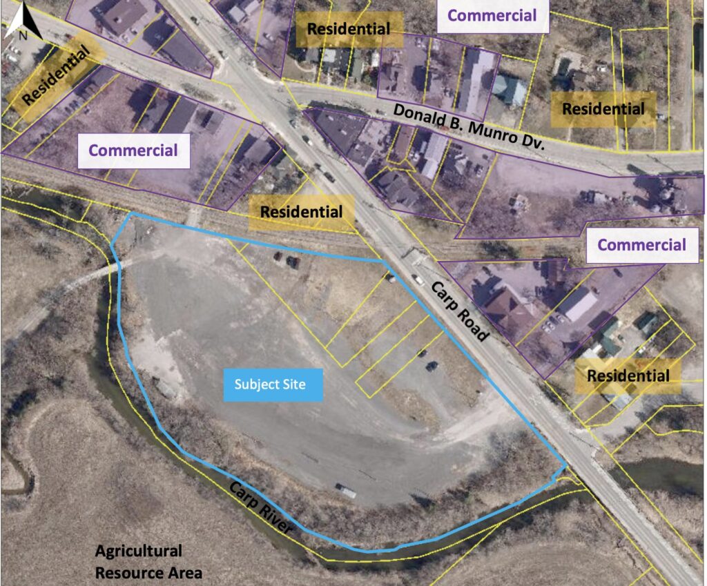
Location of proposed development beside the Carp River. Application # D07-16-23-0008
Location of proposed development beside the Carp River.

Friends of the Carp River reviewed the application documents, particularly the Planning Rationale and Design Brief, Environmental Site Assessment, Environmental Impact Statement, and Draft Plan of Subdivision.

Brief overview of the proposed development.

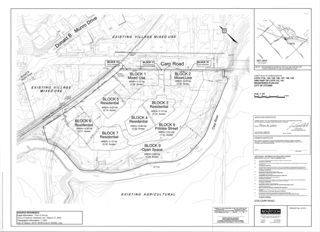
The development consists of two mixed use blocks on Carp Road with commercial space on the ground floor and two floors of nine residential units above. There are five blocks of stacked residential dwellings with twelve units each. Total residential space is 78 units.

The development is adjacent to the Carp River and its floodplain. A 30 meter vegetated buffer is maintained between the river and the parking lot. Some of the parking spaces lie within the 100 year flood line.

Draft Plan of Subdivision for 3711 - 3725 Carp Road beside the Carp River. Application # D07-16-23-0008
Draft Plan of Subdivision for 3711 – 3725 Carp Road beside the Carp River.
Our comments.

We submitted our comments to the City and to Councillor Kelly.

Friends of the Carp River welcome the development of this property.  This is an opportunity to remove an eyesore from the entrance to the village, remediate contaminated land, add medium density housing to Carp, and showcase the Carp River with a pathway along the buffer strip that will be improved with native plants.

We have three comments on the application.

1. The creation of a pathway in the floodplain’s 30m buffer area must be part of the project.

2. The site is nesting habitat for Snapping turtles. Suitable nest area(s) must be constructed to replace the nesting area being lost.

3. The site lies within Source Water Protection Area: Well Head Protection Area C for the village of Carp.  Care must be taken with how the site’s contamination is dealt with during construction.

1. Construct a pathway along the river.

The City must require a community pathway along the river as part of site plan approval.

As the application notes, a pathway along the river at this site is included in the 2012 Carp Community Design Plan, but for some reason the application has punted its creation to some indefinite future action.

The best (and cheapest) time to construct such a pathway is when there is equipment on the site and when the buffer area is being remediated with native plantings as per the Environmental Impact Statement. 

Other arguments include supporting the city’s new Official Plan, particularly under Healthy and Inclusive Communities.

We also strongly support the Environmental Impact Statement’s recommendations for native plantings in the buffer area.
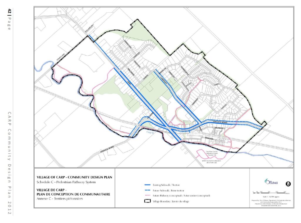
The Carp Community Design Plan (2012) clearly shows a community pathway along the Carp River at the proposed development site.
2. Add turtle nesting sites.

As part of the buffer strip improvement, two or three turtle nesting sites should be created.

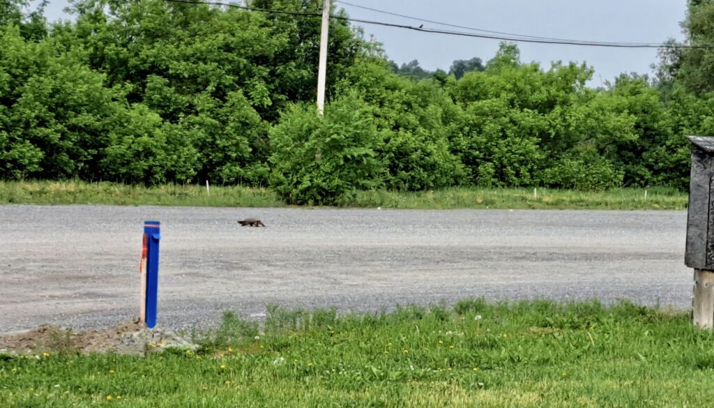
Another local organization, Friends of the Carp Hills, ran a turtle conservation project in Carp this year with support from the Canadian Wildlife Federation. The edge of the parking lot is heavily used by Snapping turtles from the Carp River for laying eggs.  Predated nests adjacent to the river are easy to find.

The Common Snapping Turtle is a Species at Risk, Special Concern.

A Snapping turtle navigates the Karson parking lot beside the Carp River during nesting season.  1 June 2023.
A Snapping turtle navigates the Karson parking lot during nesting season. 11 June 2023.
3. Site contamination must be carefully remediated.

The Phase 1 Environmental Site Assessment describes the contamination of the site from its previous use as a garage and fuel storage area.

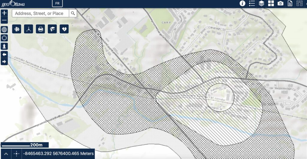
The site lies within Source Water Protection Area: Well Head Protection Area C for the village of Carp (see Figure 1).

Given the site’s soil contamination, care must be taken to protect both the river and Carp’s municipal well head in the village during construction.

Well head protection area within the village of Carp.  (source: geoOttawa)
Well head protection area within the village of Carp. (source: geoOttawa)

Comments on Arcadia Riverchase Park

Prior to the pandemic shutdown in March 2020, Friends of the Carp River had met with representatives of the Arcadia Community Association, Councillor Jenna Sudds, and city staff to discuss the design of Riverchase Park.  Our goal has been to influence the design of the park such that it reflects the spectacular natural setting of the adjacent Carp River Conservation Area.

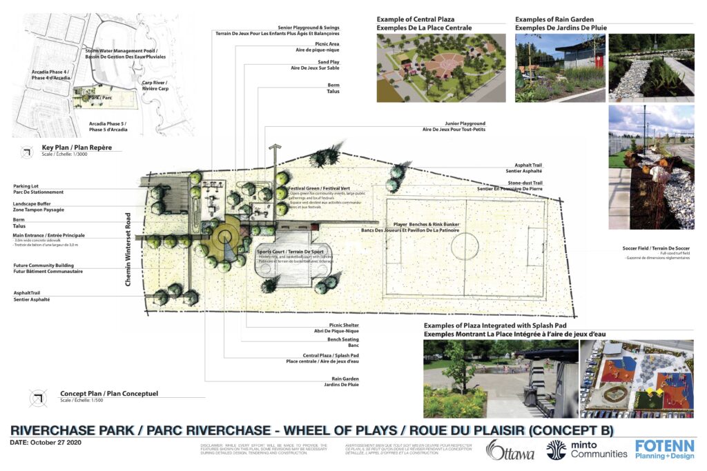
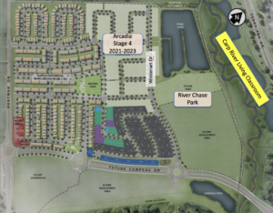
Through Engage Ottawa in December 2020, the City of Ottawa proposed two design concepts for Riverchase Park, which has a large storm water pond on its west side and the Carp River Conservation Area to its north.

Arcadia Riverchase Park Concept B
Arcadia Riverchase Park, Concept B (City of Ottawa, December 2020)

The Setting for Riverchase Park

In November, the Mississippi Valley Conservation Authority (MVCA), in partnership with Friends of the Carp River and the Ottawa Stewardship Council, launched the Carp River Conservation Area in the adjacent restored floodplain of the river.  At the Conservation Area, MVCA also launched Phase 1 of the Carp River Living Classroom with welcome signs and interpretive signs, a video, a citizen science project in iNaturalist, and a brochure.  Planning has begun for Phase 2, which will include a classroom gazebo, osprey nesting platform, educational mobile app for kids, and curriculum development with local school boards.  The site is unique in offering learning about a riverine restoration and ecosystem services provided by green infrastructure in a densely developed area.
 
The Arcadia Community Association and the City of Ottawa will determine the amenities that Riverchase Park offers its residents within the funding envelope provided.  What we would like to influence is “how” these amenities are integrated with the site.  We would also like to explore what additional features could be incorporated (e.g. art, enhanced vegetation planting, interpretive signs) if more funding were provided.

Our Comments on the Park Design Concepts 

Here are our comments, which apply equally to both design concepts.

  • It was always our fear that the park design would be another cookie cutter version of all the other new parks in the city with no acknowledgement of its spectacular setting.   Sadly, the designs presented include standard, AutoCAD-type cut-out park features that have been arranged in a utilitarian manner to fit the terrain.
  • The paths are straight lines.  Curved paths would echo the meander of the river, inviting people on a journey to the park’s amenities.  Curves are also more psychologically restful since they resemble the curves of nature.
  • Similarly, the park’s amenities near Winterset Road are laid out on a grid pattern.  There is room to rearrange these to reflect curves and circles.
  • The rain garden is a nice idea, but it should be more organic to the landscape.
  • We recognize the need for open space and ease of maintenance.  Curves are easy to mow.
  • The north side of the soccer field by the river will be elevated about 4 meters above the conservation area path, offering quite a nice view of the river and wetlands.  Can we take advantage of this with an observation area?
Riverchase Park: imagine it as a tributary of the Carp River

A good design needs a concept or theme to unify it.  Here is an idea for Riverchase Park:  imagine it as a tributary of the Carp River.

  • Either Concept A or B can be laid out with flow in mind.  People will flow down the meandering paths through the amenities to the storm water pond or to the soccer field. The vegetation plantings will run along the “river banks”.  The artwork can be turtles and birds and cattails, perhaps some spouting water near the splash pad (same pipes for running water that are drained in winter).
  • The straight line design becomes curves. The festival field is a circle or ellipse with plantings to emphasize this.
  • The splash pad would shift slightly to accommodate a pathway that flows around it on both sides as if it were a rock in a stream.  This theme could be carried through the design around the splashpad (e.g. rocks that people can sit on).
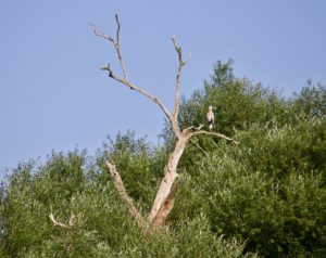
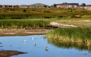
  • Great Blue Heron in the area near the location of the future park.

    A stone dust observation area would be added at the north end.   It would have benches and an interpretive sign, which could have pictures of birds that people could expect to see in the river below.  Native flowering shrubs would be added on the slope.  There should be sufficient space to allow mowing between the soccer field and the observation area.

  • An interpretive sign would be added to the path where it joins the storm water pond area.  This sign would tell people how the park, the storm water pond, and the conservation area are all linked, green infrastructure.
  • Berms and swales can be used to delineate areas and vegetation plantings, which would consist of trees and native flowering shrubs.
  • Blanding’s turtles at the Mlacak Centre in Kanata.

    Artwork would be added.  Ideally the artwork would allow kids to interact with it; e.g. like the stone turtles at the Mlacak Centre Library.

  • The curved-based design would be visually interesting, mentally restful, and more organically integrated with the surrounding landscape.
Riverchase Park:  An Opportunity for Arcadia

Adding artwork and other features to the park would increase the cost outside the envelope. There are opportunities to explore fundraising as part of the effort for the Carp River Living Classroom.

We hope that residents of Arcadia, the City of Ottawa, and the landscape architects see the same opportunities as we do for making this park more harmonious with nature.

The new storm water management pond adjacent to Riverchase Park is connected to the Carp River. The pond’s overflow is filtered by the river’s wetlands, a great example of ecosystem services provided by a natural area.

iWonder? Arcadia Riverchase Park

Arcadia lies on the Ribbon of Life of the restored Carp River.

Greek mythology imagined Arcadia as a vision of pastoralism and harmony with nature*.  In Kanata, the new community of Arcadia lies on the doorstep of a riverine and wetland natural setting – a ribbon of life – along a two kilometer restored section of the Carp River.  How fortunate Arcadia is to be part of this large and unique natural area in suburban Ottawa.  What are its possibilities for realizing harmony with nature?
 
The Friends of the Carp River are working with the Mississippi Valley Conservation Authority, City of Ottawa, and Ottawa Stewardship Council to animate the restored river and its wetlands for education and discovery, a Living Classroom along the Carp River:

  • an education resource for schools,
  • a place for families to learn about wetlands and biodiversity,
  • a site for citizen science and research,
  • perhaps eventually an eco-tourism experience for visitors to Ottawa.

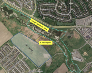
Beside the Living Classroom on the restored river lies a 6 acre parcel of land designated for a park in the Arcadia subdivision. Riverchase Park will be built with recreation amenities to meet Arcadia’s needs.  But it can be so much more than just another suburban park.  It’s a gateway to nature, connecting the community to the pulsing vitality of riparian shorelines:  wading birds, pollinators and wildflowers, basking turtles, river otters, and the seasonal rhythm of migrating birds.

Carp River, Living Classroom, Arcadia, Riverchase Park
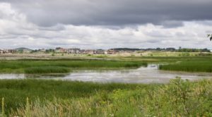
The Carp River Living Classroom lies on a 2 km section of restored river beside Terry Fox Drive between Richardson Side Road and the Queensway. Arcadia and its park lie to the south of the river.

Carp River, Living Classroom, Arcadia, Riverchase Park
Arcadia’s River Chase Park will be a gateway to the Living Classroom and Ribbon of Life along the Carp River.


iWonder – How can Arcadia’s park be:

  • a place for inspiration, recreation, gathering, and learning?
  • integrated with the river, wetlands, and wildlife?
  • a celebration of the ribbon of life?
  • an experience that is about more than just playing or watching a game?
  • a place for meditation, contemplation, and well-being?

 
The community will decide what play structures, sports, and other recreation activities go into Riverchase Park.  However, the community also has an opportunity to enhance their park experience by incorporating design features that integrate the park with its remarkable surroundings, within budget constraints.
 
This opportunity comes about through the partnership of organizations who are developing the Living Classroom.  We are talking with Councillor Jenna Sudds and the Arcadia Community Association to explore the possibilities for the park.
 
The Living Classroom is a multi-year project that will be launched later in 2020 along with a fundraising campaign.  Part of the Living Classroom vision requires a River House – a gathering and education place.
 
This is Arcadia’s opportunity to create a unique park experience in Ottawa.  We will continue to explore the possibilities with the community to live in harmony with and celebrate the ribbon of life in its backyard.
 
Councillor Sudds will be hosting a community session in Spring 2020 and a consultation website will be launched to gather community input. [Postponed due to the pandemic.]
 

Heron at the Carp River Conservation AreaShorebirds at the Carp River Conservation Area.


* from Wikipedia
 

Public Meeting on Next Phase of Arcadia Development

Originally published in July 2018.

Many people don’t know that more houses will be built between the south side of the Carp River and the existing houses in Arcadia on what used to be the floodplain of the river.  At the public meeting on 12 July we learned: 

  • There are two storm water management ponds. The larger one to the north is 8 ha and it must be built first in 2019/2020 to establish elevation.
  • In Stages 3 and 4, 455 residential units will be built, a mix of singles and townhomes.  Stage 3 planned occupancy is 2021; Stage 4 is 2024.
  • There are currently no plans to build Stage 5 (although this may change). It lies in the floodplain and there are “soil challenges”.
  • Feedmill Creek with be “restored” (with developer funds) and pathways created on either side.  The work will be done by the City in 2020.
  • The park is 6 ha.  Half of the park will be built in 2020/2021; the other half near river will need to be pre-loaded and allowed to settle.  The land will need to be raised by 3 to 4 meters.
  • The future LRT corridor is at the south end, between Campeau and the Queensway. It will cross the Carp River and run parallel to Feedmill Creek.
  • Stage 2 is commercial development south of Campeau Drive: 2 hotels, 2 restaurants, and a hotel in 2018/2019.


Concrete Batch Processing Plant Proposed for Carp Road Site

Originally published in December 2018

Huntley Creek may be threatened by a Concrete Batch Processing Plant proposed for 2596 Carp Road.  Huntley Creek is one of the City’s few cold water creeks and a tributary of the Carp River. Despite setbacks from the floodplain and vegetative buffers, discharge from the plant – planned or unplanned – could affect the creek’s temperature and introduce pollutants. There are also risks to groundwater and nearby wells.

The development proposed in the Site Plan application includes a concrete batching plant, site parking, truck parking, outdoor aggregate storage, and an outdoor wash rack. The plant will increase heavy truck traffic on an already congested section of Carp Road.

The subject property is currently zoned Rural General Industrial which permits a variety of industrial uses, but does not permit a concrete batching plant. The Zoning By-law Amendment application requests that a concrete batching plant be included as an additional permitted use to the subject property in order to accommodate the development on the property.

The target date the application will be considered by the City’s Agricultural and Rural Affaires Committee, is February 7, 2019.  Residents are encouraged to voice their concerns to Councillor El-Chantiry and to the City’s planner, who can be contacted via the Site Plan application web site.


Kanata Highlands Development

Originally published in December 2017

Richcraft Homes held a public information meeting on 12 December to share three preliminary concept plans for the envelope of land – about 27 hectares – available for development out of a total of 77 hectares on the south side of Terry Fox Drive.  Information about this project, including past comments from the public, is available at the City of Ottawa’s Urban Expansion Study for the Kanata Highlands.  The three concepts can be downloaded here.

There are two main issues with this development:

  1. management of flood and surface water, and
  2. addressing the species at risk on the site, especially the Blanding’s Turtle population.

The site borders the stretch of the Carp River between Richardson Side Road and the railroad crossing at Huntmar Road.  Flood plain mapping was last done in 1983, but significant development has occurred upstream since that time.  Blanding’s Turtles cross the site from the adjacent South March Highlands to reach the river.  We sent our comments to the City and you can download them here.